From the Pleasant Hill National Weather service site....
April 25-27, 2009 - Severe Weather and Heavy Rainfall Impact the Area
...Heavy Rain and Severe Weather - April 25-27, 2009...
A series of potent upper level disturbances along with an increasing amount of moisture streaming northward out of the Gulf of Mexico produced a period of very active weather across the central United States. Several rounds of severe weather and flooding was the end result, with many locations receiving upwards of 2 to 4 inches of rainfall. However, the biggest story from the weekend was the tornadic activity Saturday afternoon and Saturday evening. For a summary and track of each tornado, please read the separate sections below.
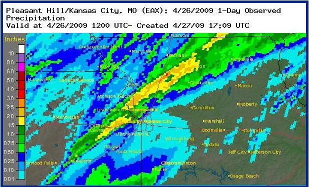
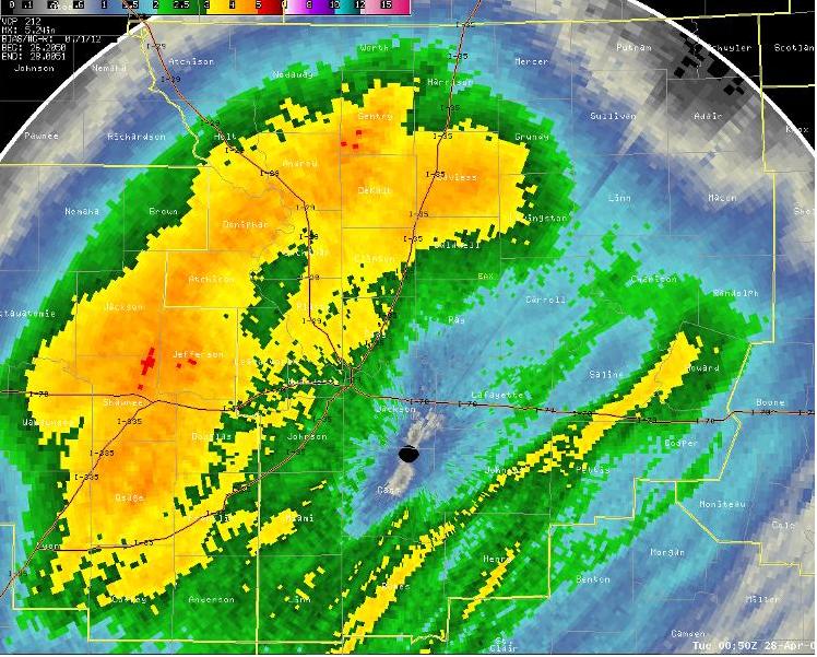
A graphical depiction of heavy rain can be viewed in the following two images. The first image depicts rainfall during Saturday afternoon and evening, with the second image depicting rainfall from Sunday morning through Monday afternoon.
Rainfall Estimates
Rainfall Estimates Saturday April 25th
Rainfall Estimates Sunday and Monday
April 26-27
Tornado #1:
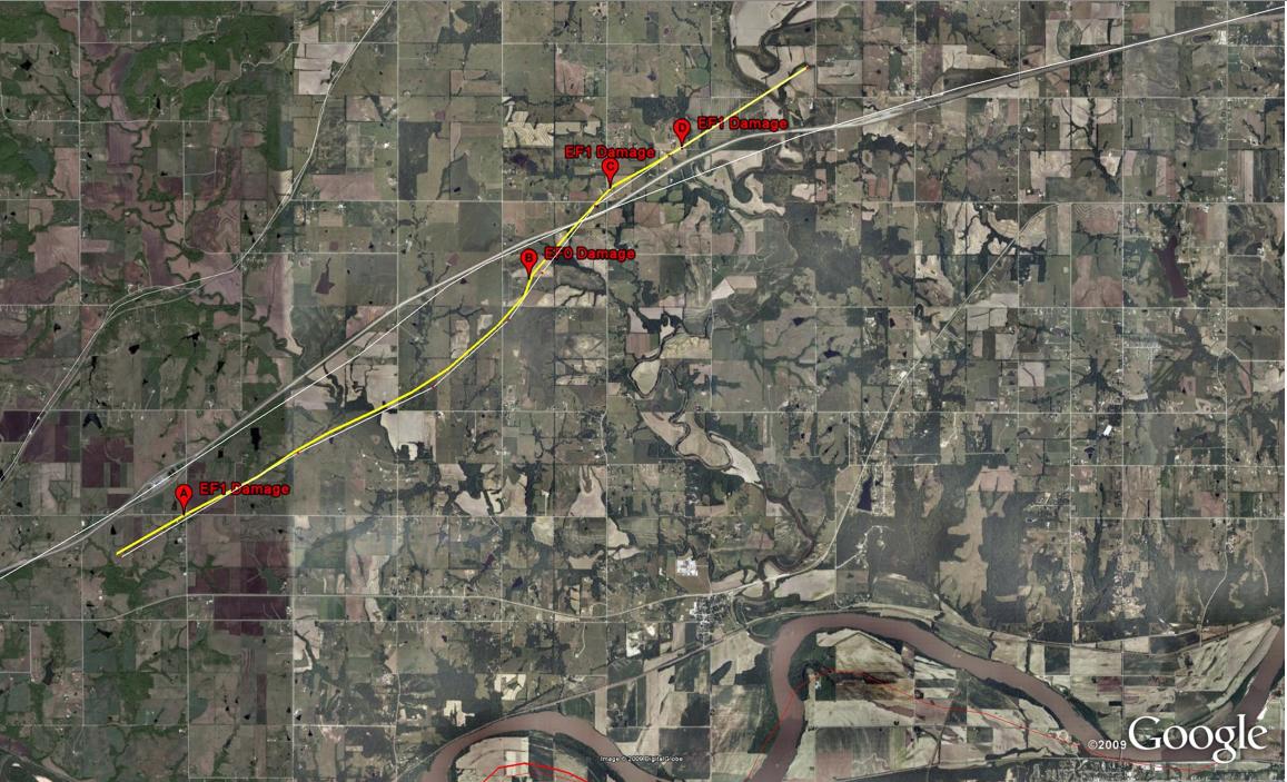
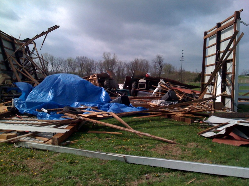
On Saturday evening, April 25th a tornado touched down in southwest Leavenworth county in Kansas at 6:35pm. National Weather Service representatives along with local emergency management officials from Leavenworth county have conducted a damage survey from the tornadic activity which occurred over southern Leavenworth county.
Initial survey results indicate damage to several homes, numerous out buildings and trees, along with additional ground scouring along the tornado path. Leavenworth This damage was produced by an EF-0 to EF-1 rated tornado, with maximum speeds between 86 and 110 mph.
The tornado produced a damage path of an estimated 8 miles, with reports and observations indicating this tornado remained on the ground around 15 minutes. Survey officials reported a damage path from 50 to 75 yards wide with two homes sustaining moderate EF-1 damage. There were also several barns damaged or destroyed. Aereal surveys indicated that this tornado touched down at 238th Street and Loring crossed I-70, and then stayed nearly parallel to the interstate as it moved northeast to near 190th Street and Metro Avenue.
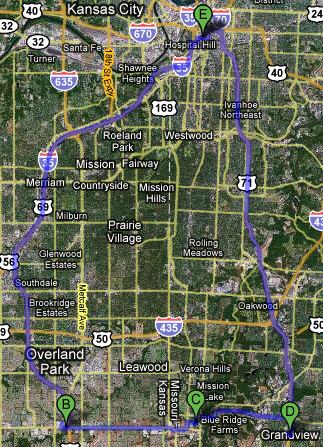
Below are several images of the indicated tornado path along with damage points indicated by points on the google maps. For more details, you can also view this file in Google Earth by downloading this KML file.
We would appreciate all photographs or videos of this tornado as it developed and produced damage. Please email your photos and videos to us at: w-eax.webmaster@noaa.gov
Tornado #2:
At 917 pm cdt, a second weak EF-0 tornado was reported Saturday evening. This brief tornado touchdown occurred just south of the city of Cameron, MO near the Cameron airport. No damage was reported with this brief touchdown.
Damage Track from Leavenworth County
Google Earth Image of Track Google Maps Image of Track
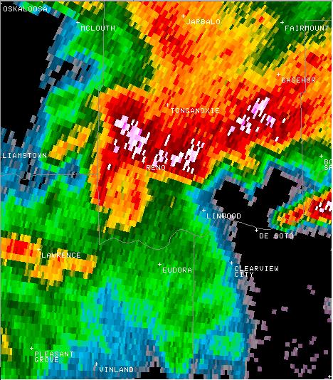
The radar images below are from 6:33pm. The first image is radar reflectivity and second is storm relative motion.
0.5 degree Radar Reflectivity 0.5 degree Radar Velocity
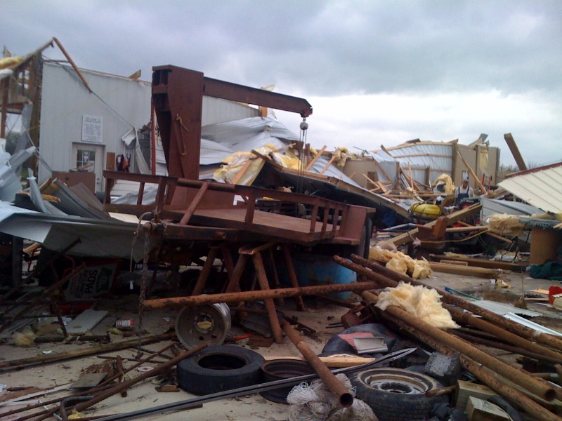
Damage Photos:
Damage from Point A on Tornado Track
Damage From Point C on Tornado Track Damage from Point D on Tornado Track
Storm Reports:
GMT Time County Location Type Magnitude Comment
04/25/2009 22:50 Daviess Winston,MO HAIL 0.75 reported at hwy 6
04/25/2009 23:07 Daviess 1 N Gallatin,MO HAIL 1 estimated golfball size hail at lake viking n of gallatin.
04/25/2009 23:22 Daviess Jamesport,MO HAIL 0.75
04/25/2009 23:28 Hancock Hamilton,IL HAIL 0.75
04/25/2009 23:32 Leavenworth 6 Sw Tonganoxie,KS HAIL 0.75
04/25/2009 23:35 Leavenworth 6 W Linwood,KS TORNADO 0 just s of i-70, 1 n of k-32
04/25/2009 23:46 Grundy Tindall,MO HAIL 0.75
04/25/2009 23:47 Leavenworth S Tonganoxie,KS HAIL 0.25 pea size hail and 60 mph winds
04/25/2009 23:50 Wyandotte W Bonner Springs,KS TORNADO 0 tornado still being reported on the ground, w of bonner springs
04/25/2009 23:55 Leavenworth 5 Nnw Linwood,KS TORNADO 0 barn destroyed
04/25/2009 23:58 Leavenworth 4 Nnw Linwood,KS TORNADO 0 reports of destruction to barns, cars upside down, and some damage to homes. location near 206th street and i-70.
04/26/2009 00:03 Leavenworth 6 N De Soto,KS FUNNEL CLOUD 0 funnel cloud report 6 n of de soto and 8 sw of leavenworth.
04/26/2009 00:20 Platte 6 S Platte City,MO HAIL 0.5 reported at i-435 and hwy 45
04/26/2009 01:34 Leavenworth 5 Sw Tonganoxie,KS TSTM WND GST 70 reported at 246th st and dehoff rd, 6 miles w of reno
04/26/2009 01:50 Leavenworth 6 Nw Basehor,KS HAIL 0.88
04/26/2009 01:50 Leavenworth 5 Nw Basehor,KS HAIL 0.88
04/26/2009 01:55 Platte Dearborn,MO HAIL 0.88
04/26/2009 02:04 Dekalb Osborn,MO HAIL 1
04/26/2009 02:17 Clinton 1 Sw Cameron,MO TORNADO 0 along a hwy near the airport
04/26/2009 02:17 Dekalb Cameron,MO TORNADO 0 along a hwy near the airport
04/26/2009 02:30 Dekalb N Osborn,MO HAIL 1
04/26/2009 02:52 Daviess 5 S Jamesport,MO FLOOD 0 3 to 4 inches of water flowing over the road at hwy v and hwy 190
04/26/2009 03:45 Leavenworth Tonganoxie,KS FLASH FLOOD 0 water rescue occurring due to flooding of tonganoxie creek
04/26/2009 04:20 Mercer Princeton,MO HAIL 0.88
Rainfall Est Sat 25 Apr 2009
http://farm4.static.flickr.com/3316/3489253725_f5a4d22141_o.jpg
Rainfall est Sun 26 to Mon 27 Apr 2009
http://farm4.static.flickr.com/3387/3489254527_78414f614d_o.jpg
Linnwood Tornado Sat 25 Apr 2009
http://farm4.static.flickr.com/3317/3490071036_a187274aae_o.jpg
Linwood Tornado Sat 25 April 2009
http://farm4.static.flickr.com/3297/3490071506_cc5c856592_o.jpg
Radar Linwood Tornado 4-25-09
http://farm4.static.flickr.com/3570/3489256653_2e9b8a09d3_o.jpg
Relative Velocity Linwood Tornado 4-25-09@18-35
http://farm4.static.flickr.com/3334/3489256759_0ab5daba47_o.jpg
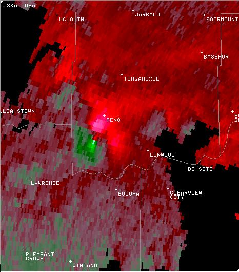
photo1
http://farm4.static.flickr.com/3377/3489256953_90857941f7_o.jpg
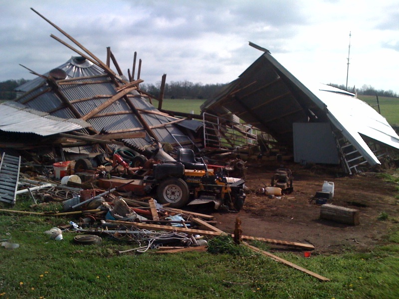
photo1-1
http://farm4.static.flickr.com/3390/3489257119_26c127dfa4_o.jpg

photo1c
http://farm4.static.flickr.com/3320/3490072316_5d264cfb94_o.jpg
photo1b
http://farm4.static.flickr.com/3364/3489257371_392e9a331b_o.jpg
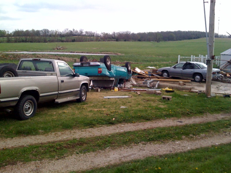
photo2
http://farm4.static.flickr.com/3408/3489257495_2b149f34a4_o.jpg
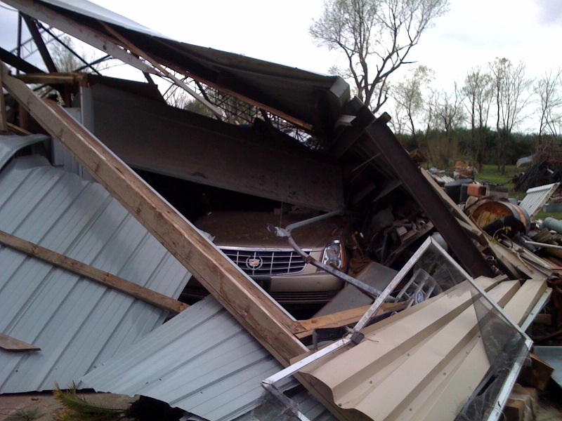
photo3
http://farm4.static.flickr.com/3541/3489257695_6bbb4035b4_o.jpg
http://www.youtube.com/watch?v=JUwFYKtGB2M
http://www.youtube.com/watch?v=9HK7tJzx9Hw
http://www.youtube.com/watch?v=439lKUpGEOI
http://www.youtube.com/watch?v=ebiU3O08kIw
http://www.youtube.com/watch?v=PVmvOhQAhOY
http://www.youtube.com/watch?v=F0-DfzZnTzs
http://www.fox4kc.com/video/?autoStart=true&topVideoCatNo=default&clipId=3692090
http://www.fox4kc.com/video/?autoStart=true&topVideoCatNo=default&clipId=3692767
http://www.fox4kc.com/video/?autoStart=true&topVideoCatNo=default&clipId=3693630
http://www.fox4kc.com/video/?autoStart=true&topVideoCatNo=default&clipId=3694239
http://www.fox4kc.com/video/?autoStart=true&topVideoCatNo=default&clipId=3697240
http://www.fox4kc.com/video/?autoStart=true&topVideoCatNo=default&clipId=3697240
On Sunday morning, while pulling cable to try to get my camera attached for a liveshot, I stepped on a nail or some sort of sharp object. In the afternoon, for precautionary measures, I went to the emergency room to have a tetanus shot. On Monday I had to process workers comp. I got some anti-biotics and have to go in on Friday, but otherwise I'm fine.
I did a little storm chasing tonight. It was nothing much, not that I expected it to be. There was one storm that started looking interesting when it popped up south of here. I was doing nothing so it was worth it to drive.
Loading the chat room...
Welcome to the chat room
9:48dannywelch:awesome....
9:48dannywelch:runnin grlevel3?
9:49stevosvoboda:no
9:49stevosvoboda:weathertap
9:49stevosvoboda:go to youtube
9:49stevosvoboda:search aurua tornado
9:50dannywelch:that you?
9:50stevosvoboda:yes
9:51dannywelch:very nice....so you chase for WDAF?
9:56stevosvoboda:i 135 & nall
9:58dannywelch:alright dude. it was nice talking to ya. Hope to see you out on the roads some day. I added your channel as a favoritte
9:58dannywelch:take er easy
10:00stevosvoboda:martin city
10:07stevosvoboda:grandview
10:35stevosvoboda:yj"S
11:10dukeivan:what is it
I streamed, and that was the chat I was having.
Stormchase, Thursday 30 April 2009
http://farm4.static.flickr.com/3392/3490676440_9bf9bb3530_o.jpg
I saw a little cell southwest starting to take on some interesting characteristics. I was pretty sure it wouldn't do much, but I decided, what the hell. So I chased to 135th and 69, then headed east on 135th, after having to restart my stream and my weathertap, due to bad cell service. I got into some heavy rain about then, and some lightening. By the time I made Grandview, I decided, whatever it was it was fizzling out. So I headed back to YJ's.
No comments:
Post a Comment